What is Geofencing and Why Do You Need It Today?
Geofencing is a location-based technology that generates instant alerts whenever a person or vehicle crosses a specific geographical area. Geofencing requires GPS, RFID, Wi-Fi, or cellular data to create boundaries around real-world geographical regions. This technology has become popular in many industries, including fleet management.
According to Fortune Business Insights, the global geofencing market size was valued at USD 2.2 billion in 2023 and is expected to reach USD 12.23 billion by 2032. This growth is driven by various factors, such as the increasing demand for location-based services and real-time analytics. This powerful GPS feature can bring great benefits to your fleet operations, and today we’re here to show you why your fleet business needs it.
What is a geofence?
A geofence is a virtual geographic boundary that triggers a specific action, such as sending a notification, when a connected device crosses into or out of the set zone. Several technologies are integrated into software to enable this application. These technological tools include a global positioning system (GPS), cellular data, radio frequency identification (RFID), or Wi-Fi.
Geofencing technology is very popular in marketing, advertising, and fleet management industries. For example, in retail, geofencing is used to send personalised alerts to the cell phones of customers who are in the vicinity of the store.
In fleet management, geofencing is used to monitor vehicle, driver, and asset movements. It also allows companies to see when drivers deviate from the recommended routes. Furthermore, geofencing helps shipping companies see when packages leave warehouses. In doing so, geofence technology allows recipients to get notifications of the movements of their orders.
How does a geofence work?
A geofence works using a cloud-based fleet management software platform. It’s created by drawing a perimeter on a map. The drawing can be any shape, and this boundary could represent places like warehouses, a restricted area, high-risk zones, or a drop-off location.
With geofencing, GPS is the primary tool used to pinpoint the live location of a device or vehicle. The RFID (Radio Frequency Identification) uses tags and readers within a smaller area for location detection in close proximity. The WiFi helps devices connect to specific networks inside buildings or urban areas.
The cellular data helps estimate the device’s location using nearby cell phone towers, and the Bluetooth technology is for beacons, which allow precise tracking in closed-in spaces like warehouses.
Types of geofences:
Why you need to invest in geofencing technology
As a fleet manager, it’s important to know where your vehicles and assets are at all times. Geofencing simplifies that by giving you the ability to create virtual fences around certain areas. These can be places that apply to the daily operations of your business. It helps you protect your fleet, reduce risks, and improve the way your fleet operates.
Here’s how:
Enhanced security, theft prevention and asset protection
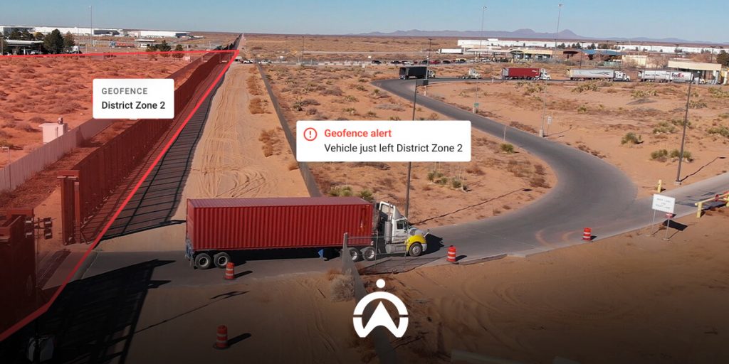
Protection against theft is one of the top priorities for every business. Geofencing helps you safeguard your vehicles and assets by monitoring entry and exit points. Whenever a vehicle crosses your set boundary, you’ll immediately know about it. For instance, if a truck leaves the parking area after hours, you’ll receive an instant alert and can quickly take action. You can also set geofences around well-known high-risk areas, reducing the chances of vehicle theft.
Better fleet and asset management
Geofencing helps you monitor movements along delivery routes or within specific job sites. In doing so, you’ll notice when drivers are deviating from routes, taking unplanned trips, or idling for too long. You can address these issues and educate your drivers on how such acts have an impact on fuel expenses and vehicle maintenance.
Improved employee and driver accountability
Your drivers play a big role in how well your fleet runs. Geofencing helps you easily monitor vehicle movements, which encourages drivers to stick to their schedules as they know they’re being watched. This improves delivery pick up and drop times, driver accountability, and the overall performance of your fleet.
How to get started with geofencing
Geofencing doesn’t have to be complicated. By choosing the right tools, understanding how they work, and setting up clear zones, you can take control of your fleet’s safety and efficiency. With some planning and staff training, geofencing can quickly become an essential part of how your fleet operates. Here’s how to get started:
- Choose the right software or service provider: It all starts with your service provider. Choose a company with geofencing tools that best fit your business needs. Some software works best for large fleets, while others are simpler for smaller operations. Look for a provider that caters to businesses of any size. They should also offer easy setup and reliable customer support.
- Define your zones based on your business needs: Choose areas that matter most to your operations. These could be warehouses, job sites, delivery routes, or even customer locations. Create geofences around these zones so you can see when vehicles or assets enter or leave these areas. Clear zones help you focus on the areas that matter most and avoid unnecessary alerts.
- Set up alerts and reporting: Once your zones are defined, set up alerts for any unusual activity. You can get notified when a vehicle leaves a zone at the wrong time or enters a restricted area. Regularly check geofencing reports to notice patterns in movement, driver behaviour, and fleet usage. This information helps you spot issues and make better decisions. In doing so, you save on fuel and maintenance costs, improve efficiency, and ensure fleet safety.
- Train staff or users on how to use the tool: Make sure everyone who uses the system knows how it works. Train your staff on how to respond to alerts and what protocols to follow when a boundary is crossed. The better your team understands the geofencing tool, the more effective they’ll be.
Case study: Geofencing for BCI Security
BCI Security is a company that offers a full range of private security protection services. They had no way of ensuring their response units remained within their assigned areas. This delayed their drivers’ response times. It also prevented their control room from being as quick and efficient as possible in emergencies. BCI Security needed a system to help them instantly locate their vehicles and monitor driver behaviour.
How we helped them:
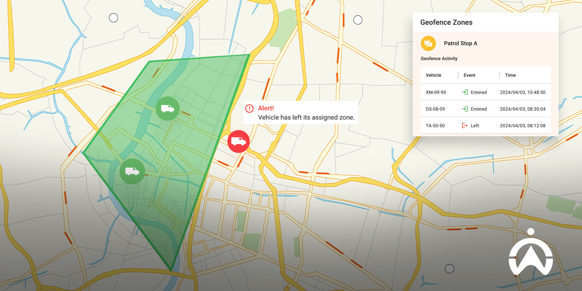
- Cartrack’s geofencing feature allows BCI to set virtual parameters around assigned areas and alert them when drivers enter or leave those zones. This helps them ensure their response units are always active and present in their assigned areas. They can respond to client emergencies as quickly as possible. The geofence reports are also useful in giving BCI’s clients an accurate indication of patrol activity in their areas and making drivers more accountable.
- BCI Security can pinpoint exactly where reaction officers are with Cartrack’s live GPS tracking feature. They’re able to locate their nearest response unit to a client, which improves response times. It also boosts accountability and service delivery, as BCI can verify that response units were at the scene.
- Their fleet managers can now monitor driver behaviour and receive alerts when drivers are speeding, braking harshly and cornering quickly. It helps you spot any dangerous driving habits that occur when there are no emergencies. This minimises incidents that could be harmful to drivers, vehicles, communities, and BCI’s business reputation. It’s also an effective way to decrease vehicle wear and tear and prolong fleet longevity.
“Cartrack suited and understood our business from the start. We feel much safer with the Cartrack system, and their service is great, you are not just a number with them. Without them, we just wouldn’t be as efficient.” Johnny Loots | CEO, BCI Security
Get started with Cartrack’s geofencing feature!
At Cartrack, all you have to do to access our geofencing feature is get a GPS tracking device. We have an easy-to-use fleet management platform that you can access in the office or on the move. With this technology, you’ll know your drivers’ every move and ensure your vehicles are never where they shouldn’t be.
Here are other features that come with the Cartrack vehicle tracking system:
- Live tracking: Our cloud-based system ensures that you get access to vehicle locations at any time. You’ll get smart satellite or map views of your vehicles, so you can monitor routes and how long drivers take with pick-ups and drop-offs. This makes it easier to spot time-wasting activities and quickly address them.
- Asset Protection: We have a highly trained team of recovery experts that’s always on standby, waiting for your call. We’ve recovered more than 100,000 vehicles over the past decade, proving that you can trust us with the safe return of your vehicles.
By investing in our geofencing technology, you give your business the tools to run a safer, smarter, and more accountable fleet. Reach out to us, and secure your fleet!
Frequently Asked Questions about Geofencing
How much does geofencing cost?
The cost of geofencing depends on the fleet management software or service you choose and how many vehicles or assets you want to track. Some service providers charge a monthly fee per vehicle, while others offer packages for fleets. You can speak to one of our fleet consultants to pick one that best fits your budget and business needs.
Is geofencing illegal?
Geofencing is not illegal when used for business purposes such as tracking vehicles, deliveries, or assets. Its use is regulated under Eswatini’s Data Protection Act No. 5 of 2022. The law requires businesses to ensure transparency and obtain user consent to avoid privacy violations. By respecting individual privacy and complying with the regulations set by the Eswatini Communications Commission (ESCCOM), geofencing remains legal and safe for your business.
How long has geofencing been around?
Geofencing has been around since the early 1990s. It became popular as GPS and mobile technology improved, making it easier for businesses to track vehicles, equipment, and people. Today, it’s widely used across many industries to improve security, efficiency, and accountability.